Federated States of Micronesia Vector EPS maps
Welcome to epsmaps.com, your go-to source for high-quality digital maps in Adobe Illustrator EPS format. Our collection includes maps for various countries, including the Federated States of Micronesia.
Our Federated States of Micronesia Vector EPS maps are designed to provide businesses with accurate and detailed information about the country’s geography, cities, and important landmarks. These maps are perfect for businesses that need to create marketing materials, presentations, or reports that require detailed information about the country.
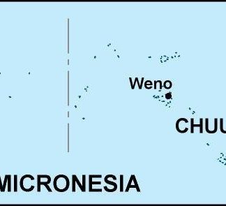
The Federated States of Micronesia is a country located in the western Pacific Ocean. It is made up of four states: Yap, Chuuk, Pohnpei, and Kosrae. Our maps provide detailed information about each of these states, including their location, major cities, and important landmarks.
In addition to state-level information, our maps also provide detailed information about the major cities in the Federated States of Micronesia. This includes information about the city’s location, population, and important landmarks.
Our Federated States of Micronesia Vector EPS maps are designed to be easy to use and customize. They are fully editable in Adobe Illustrator, allowing businesses to add their own branding, colors, and other customizations.
Overall, our Federated States of Micronesia Vector EPS maps are an essential tool for businesses that need accurate and detailed information about the country’s geography, cities, and important landmarks. Visit epsmaps.com today to learn more about our collection of digital maps.
Showing all 4 resultsSorted by latest
-

federated states of micronesia illustrator eps map vector
29.00 € Select options -
federated states of micronesia political eps map vector
99.00 € Select options -
federated states of micronesia blind eps map vector
35.00 € Select options -
federated states of micronesia eps map vector
39.00 € Select options

Showing all 4 resultsSorted by latest