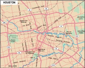
Houston city eps map vector
65.00 €
The Houston city eps map vector available on epsmaps.com is a high-quality map designed using Adobe Illustrator. It is a vector format, which means that it can be scaled to any size without losing its resolution. This makes it perfect for use by businesses and professionals who need to print large maps for presentations or marketing materials.
Houston is located in the state of Texas, in the southern United States. The city is known for its oil industry, as well as its diverse population and cultural attractions. The Houston city eps map vector shows the city’s major streets and highways, as well as its neighborhoods and landmarks.
Some of the main streets in Houston include Westheimer Road, which runs through the heart of the city and is home to many shops and restaurants, and the Katy Freeway, which is one of the busiest highways in the country. Other notable landmarks on the map include the Houston Museum of Natural Science, the Space Center Houston, and the Houston Zoo.
Overall, the Houston city eps map vector is a valuable resource for anyone who needs to navigate the city or showcase its features to others. Its high-quality design and detailed information make it a must-have for businesses and professionals in the Houston area.


