Description
saint lucia vector map. Vector maps from Central America and Caribe Illustrator EPS files, fully editable from our American Country map database. All our digital cartography was created with Vector Adobe Illustrator
Vector eps City maps of the cities and countries of the world. More than 10 000 vector files
39.00 €
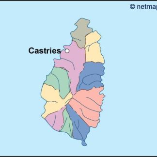
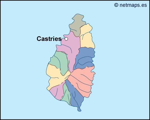
Saint Lucia is a small island nation located in the eastern Caribbean Sea. The country is part of the Lesser Antilles and is situated north of Saint Vincent and the Grenadines and south of Martinique. The capital of Saint Lucia is Castries, which is located on the northwest coast of the island.
The Saint Lucia EPS map vector is a detailed representation of the country’s geography, including its coastline, mountains, and major cities. The map is designed to be used in a variety of applications, including tourism, education, and business.
The map is created using vector graphics, which means that it can be scaled to any size without losing its quality. This makes it ideal for use in print materials, such as brochures and posters, as well as digital applications, such as websites and mobile apps.
The map includes a range of features that make it easy to navigate and understand. The coastline of Saint Lucia is clearly defined, with all major bays and inlets marked. The island’s interior is also well represented, with the major mountain ranges and rivers clearly marked.
In addition to the geography of the island, the map also includes a range of cultural and historical landmarks. These include the Pitons, which are two volcanic spires that rise up from the sea and are a UNESCO World Heritage Site. The map also includes the capital city of Castries, which is home to a range of historic buildings and cultural attractions.
The Saint Lucia EPS map vector is designed to be easy to use and customize. The map is available in a range of formats, including Adobe Illustrator and EPS, which means that it can be edited and customized to suit the needs of any project.
Overall, the Saint Lucia EPS map vector is an essential tool for anyone looking to explore or do business in this beautiful island nation. With its detailed geography, cultural landmarks, and customizable format, the map is an invaluable resource for anyone looking to promote or understand Saint Lucia.
saint lucia vector map. Vector maps from Central America and Caribe Illustrator EPS files, fully editable from our American Country map database. All our digital cartography was created with Vector Adobe Illustrator