Description
austria vector map. Vector maps from Europe. Illustrator EPS files, fully editable from our european Country map database. All our digital cartography was created with Vector Adobe Illustrator
Vector eps City maps of the cities and countries of the world. More than 10 000 vector files
39.00 €
Austria is a beautiful country located in the heart of Europe. It is bordered by Germany to the northwest, the Czech Republic to the north, Slovakia to the northeast, Hungary to the east, Slovenia and Italy to the south, and Switzerland and Liechtenstein to the west. The capital of Austria is Vienna, which is also the largest city in the country.
The country is known for its stunning Alpine scenery, rich cultural heritage, and vibrant cities. It is a popular tourist destination, attracting millions of visitors every year. The country is also home to many famous musicians, artists, and writers, including Mozart, Beethoven, and Freud.
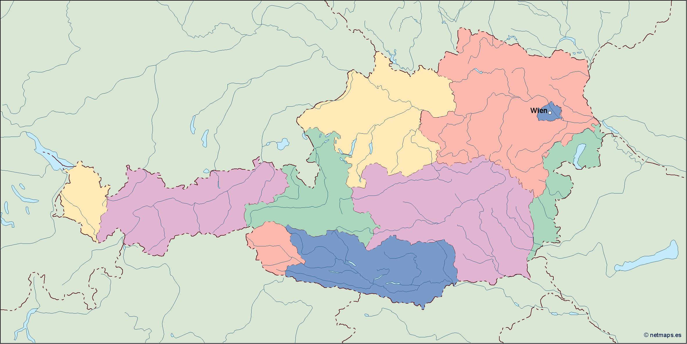
The map of Austria in EPS vector illustrator format is a detailed representation of the country’s geography, including its borders, major cities, and natural features. The map is designed to be used for a variety of purposes, including educational materials, travel guides, and marketing materials.
The map includes all of the major cities in Austria, including Vienna, Graz, Linz, Salzburg, and Innsbruck. Each city is clearly labeled and color-coded to make it easy to identify. The map also includes major highways, railways, and airports, making it easy to navigate the country.
In addition to the cities, the map also shows the natural features of Austria, including the Alps, the Danube River, and Lake Constance. The Alps are a major feature of the country, and the map shows the location of all of the major mountain ranges, including the Hohe Tauern, the Ötztal Alps, and the Karwendel Range.
The map also includes information about the country’s administrative divisions. Austria is divided into nine states, each with its own capital city. The map shows the location of each state and its capital, making it easy to understand the country’s political geography.
Overall, the map of Austria in EPS vector illustrator format is a valuable resource for anyone interested in the country. It provides a detailed and accurate representation of the country’s geography, making it easy to navigate and understand. Whether you are a student, a traveler, or a marketer, this map is an essential tool for exploring all that Austria has to offer.
austria vector map. Vector maps from Europe. Illustrator EPS files, fully editable from our european Country map database. All our digital cartography was created with Vector Adobe Illustrator